Daedong:
Korea Heritage Map대동명소도
A black-and-white, ink-wash map of Korea with 306 heritage landmarks. Visit a site in person to stamp it in your own stamp book. Built with AI, from the map data to the App Store release.수묵화처럼 그린 흑백 한반도 지도에 명소 306곳을 담았습니다. 현장 가까이 가면 도장을 찍어 도장첩을 채웁니다. 지도 자료부터 앱스토어 출시까지 AI와 함께 만들었습니다.
- How it was made만든 방식
- 76 of 78 commits co-authored by Claude커밋 78개 중 76개를 Claude와 공동 작성
- Platform플랫폼
- iPhone, iOS 17 or later아이폰, iOS 17 이상
- Built with기술
- SwiftUI, no outside libraries or map servicesSwiftUI. 외부 라이브러리와 지도 서비스 없이 만듦
- Status상태
- Released, v1.0, free출시, 1.0 버전, 무료
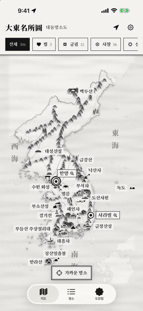
The ink map with 306 landmarks명소 306곳이 놓인 수묵 지도
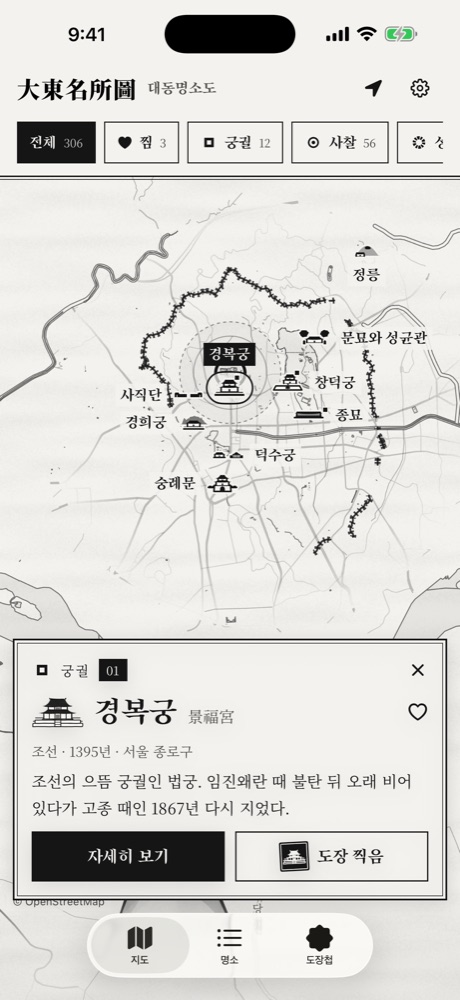
Zoom in, tap a marker for a card키우고 표식을 누르면 해설 카드
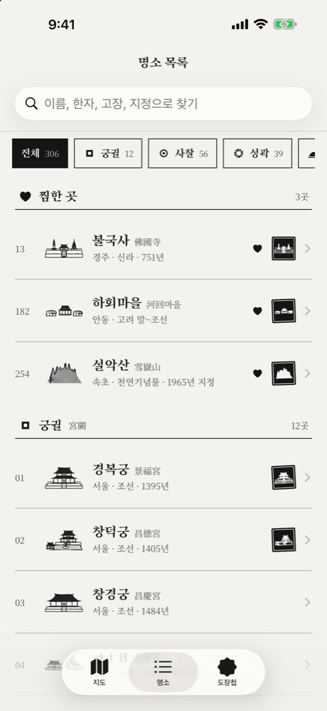
List and search목록과 찾기
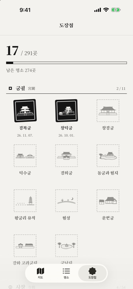
Stamp book도장첩
What it does무엇을 하나요
Ink-wash map수묵 지도
Mountains are layered in ink, rivers drawn as double lines and old roads marked with ticks, following the 19th-century atlas Daedongyeojido. Zoom in and the detail grows. At Hanyang (old Seoul) and Seorabeol (old Gyeongju) you can go down to palace grounds, ancient tombs and the old city walls.대동여지도의 표현을 따라 산줄기는 먹으로 겹쳐 그리고, 물줄기는 겹선으로, 옛길은 눈금으로 나타냈습니다. 키울수록 더 자세해지고, 한양과 서라벌은 궁궐과 고분, 옛 도성의 자리까지 들어갑니다.
306 landmarks, 8 types명소 306곳, 8가지 종류
Palaces, temples, fortresses, royal tombs, academies and schools, villages and old houses, pagodas and stone monuments, and scenic places. Filter by type. At full view only top-tier sites show, and more appear as you zoom in.궁궐, 사찰, 성곽, 능묘, 서원과 향교, 마을과 고택, 탑과 석조물, 자연 명승입니다. 종류별로 걸러 볼 수 있고, 반도 전체에서는 1등급 명소만 보이다가 키울수록 나머지가 나타납니다.
Stories and photos해설과 사진
All 306 landmarks have a description and a story, 302 have a “did you know” note, and 287 have a photo. Photos show in black and white and turn to full color once you stamp the site.306곳 모두 해설과 이야기가 있고, 302곳에는 재밌는 이야기가, 287곳에는 사진이 있습니다. 사진은 흑백으로 보이다가 도장을 찍으면 원래 색으로 바뀝니다.
Stamp book도장첩
Each site has its own seal, and you can stamp it only when you are near the real place, usually within 1 km. 291 sites can be stamped. The 15 in North Korea are map and text only.명소마다 도장이 하나씩 있고, 실제 장소 가까이 갔을 때만 찍을 수 있습니다. 거리는 대부분 1km 안입니다. 도장은 갈 수 있는 291곳 기준이고, 북한 땅 15곳은 지도와 해설로만 봅니다.
Search, favorites, nearest찾기, 찜, 가까운 명소
Search by name, hanja, region, period or designation. Save favorites and show only those on the map. One button finds the landmark nearest to you, and your position shows with a 1 km ring.이름, 한자, 고장, 시대, 지정 종류로 찾습니다. 찜한 곳만 지도에 모아 볼 수 있고, 버튼 하나로 가장 가까운 명소를 찾습니다. 내 위치 둘레에는 1km 원이 그려집니다.
Offline and private인터넷 없이, 추적 없이
It works without an internet connection. No account, no ads, no tracking. Location is used only to show your position and check stamp distance, and it is never stored or sent. Korean and English can be switched in Settings.인터넷 연결 없이 쓸 수 있습니다. 계정도 광고도 추적도 없습니다. 위치는 내 자리를 보이고 도장 거리를 재는 데만 쓰고, 저장하거나 보내지 않습니다. 설정에서 한국어와 영어를 고를 수 있습니다.
Ink lines that stay sharp when you zoom.키워도 흐려지지 않는 먹선
76/78
commits co-authored by Claude (74 with Opus, 2 with Sonnet)Claude(Opus 74개, Sonnet 2개)와 공동 작성한 커밋 수
-
01
The map is data, not a picture지도는 그림이 아니라 자료
Coastlines, rivers, ridges and roads are lists of lines and shapes in JSON. A tiled layer redraws only the visible pieces at each zoom, so ink lines stay crisp up to 128x.해안선, 강, 산줄기, 옛길은 선과 면을 담은 JSON입니다. 타일 레이어가 보이는 조각만 그 배율에 맞춰 다시 그려서, 최대 128배까지 키워도 먹선이 선명합니다.
-
02
No outside parts외부 부품 없이
SwiftUI for iOS 17 and up, with no outside libraries and no map service. Node scripts build the map and landmark data, and Python’s fonttools trims the font down.SwiftUI로 iOS 17 이상을 만들었고, 외부 라이브러리도 지도 서비스도 쓰지 않습니다. 지도와 명소 자료는 Node 도구로 만들고, 글꼴은 Python fonttools로 줄였습니다.
-
03
Checked sources출처를 확인한 자료
Landmark coordinates come from Korea Heritage Service public data and were cross-checked with Wikidata and OpenStreetMap. Descriptions were checked against the Korea Heritage Service and the Encyclopedia of Korean Culture.명소 좌표는 국가유산청 공개 자료를 바탕으로 하고, Wikidata와 OpenStreetMap으로 맞춰 보았습니다. 해설은 국가유산청과 한국민족문화대백과 자료를 확인해 썼습니다.
-
04
Rules for the AIAI에게 알려 준 규칙
The repo keeps a CLAUDE.md and an AGENTS.md that describe the app, its rules and its current state for AI coding tools.저장소에 CLAUDE.md와 AGENTS.md를 두고, 앱의 설명과 규칙, 지금 상태를 AI 코딩 도구가 읽을 수 있게 적어 두었습니다.
By the numbers.숫자로 보면
Landmarks명소
306
landmarks in 8 types8가지 종류의 명소
Stampable도장
291
sites you can stamp in person현장에서 도장을 찍을 수 있는 곳
North Korea북한
15
map and text only, no stamps지도와 해설만 있고 도장은 없는 곳
Photos사진
287
landmarks with a photo사진이 있는 명소
Zoom확대
128×
maximum zoom on the ink map수묵 지도의 최대 확대 배율
Commits커밋
78
from Oct 25 to Nov 2, 20262026년 10월 25일부터 11월 2일까지
Where the data comes from.자료는 어디서 왔나요
Credits are in the app too. The photographer and license of each photo are listed in Settings.앱 안에서도 출처를 밝힙니다. 사진마다 촬영자와 이용 조건을 설정에서 볼 수 있습니다.
Map지도
Coastline and rivers from Natural Earth, detailed maps from OpenStreetMap, elevation from Copernicus DEM. The mountain ridges and the remaining rivers follow approximate routes, not survey data.해안선과 강은 Natural Earth, 자세한 지도는 OpenStreetMap, 고도는 Copernicus DEM 자료입니다. 산줄기와 나머지 강줄기는 측량 자료가 아니라 대략의 경로를 따랐습니다.
Landmarks명소 자료
Coordinates come from Korea Heritage Service public data, cross-checked with Wikidata and OpenStreetMap. Text was checked against the Korea Heritage Service and the Encyclopedia of Korean Culture.좌표는 국가유산청 공개 자료를 바탕으로 Wikidata, OpenStreetMap과 맞춰 보았습니다. 해설은 국가유산청과 한국민족문화대백과 자료를 확인해 썼습니다.
Photos사진
Photos come from Wikimedia Commons, the Korea Heritage Portal and the KOGL website, each used under its own license.사진은 위키미디어 공용, 국가유산포털, 공공누리 누리집의 자료를 각각의 이용 조건에 따라 썼습니다.
Status and links.현황과 링크
At a glance한눈에 보기
- Status상태
- Released출시
- Version버전
- 1.0, free, Travel category1.0 버전, 무료, 여행 분류
- Released출시일
- Nov 2, 20262026년 11월 2일
- Next다음
- In progress제작 중An Apps in Toss version앱인토스 버전
Links링크
- App StoreApp Store
- Daedong: Korea Heritage Map대동명소도
- Support지원
- Support page지원 페이지
- Privacy개인정보
- Privacy policy개인정보 처리방침